Headington Farmers’ Market vs Doric

Headington Farmers’s Market got sick and tired of Doric Properties using them to further their own private interests. HFM told Doric to stop.

Doric had a reply.

You can see the exchange here: https://www.facebook.com/pages/Headington-Farmers-Market/415403325525?ref=ts&fref=ts. Scroll down the page to the entry for 12 July.

I think you should be able to see this page even if you aren’t a registered Facebook user. I know such people can see my page. You just can’t leave a comment if you aren’t. If you find you cannot see this page, leave a comment here and I’ll help.

Campaign to protect Oxford Greenbelt

2014 cumnor cricket siteI’ve been helping the local Lib Dems get support in Cumnor, Botley, Sunningwell and South Hinksey for their campaign to get the Vale adminstration to look again at the proposed plans to build piecemeal on the Oxford Green Belt.

Residents have been so supportive, signing on the doorstep when we call, or via our online petition. A big Thank You to everyone who has signed our petition so far.

If you haven’t signed already, please sign the petition to help protect the Green Belt. You can do it online here: http://oxwablibdems.org.uk/en/petition/don-t-build-on-the-green-belt-petition

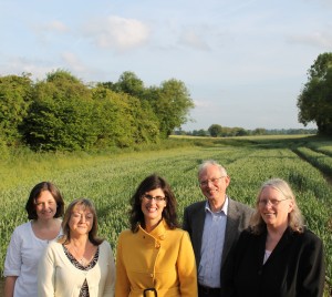
PS. Did you know they plan to build 200 houses in the Green Belt land behind the Cumnor cricket gounds? (Right behind us in the photo above.) Did you know the Vale’s consultants recommend removing the Fogwell Road Pavilion Grounds and the Louie Memorial Pavilion and all the upper playing fields from the Green Belt protection?

I was astonished to learn that. I signed the petition. I’ll let you know when we are going to present it to the Vale. Maybe you’ll want to come along.


Who Clears the Graffiti?

Graffiti clear Jul 14 We’ve had a recent spate of graffiti here in Botley. Well, if May is considered ‘recent’.

In the spring, we were tagged with ‘Mango’. It was everywhere: bus shelters, utility cabinets, buildings in West Way, A34 underpasses, grit bins, other places. The Louie Memorial Pavilion was a big target.

So, you may ask, who is responsible for cleaning it up? Vale? County? Parish? Me?

I went to the Vale officers in late May to ask for advice and help. Officers from the Community Safety team visited the area and called on owners of some of the defaced property, and also notified the police to be vigilant.

Some of the tagging has been cleaneStella Bella Stellad up, but not all.

The Vale website has information about who is legally responsible for clean-up: http://www.whitehorsedc.gov.uk/services-and-advice/environment/street-cleaning/graffiti

Essentially, the owner of the property is responsible for its removal.

For phone boxes and utility cabinets, it is the relevant company (numbers are on the website).

For bus stops, it’s the county council.

For bus shelters, it’s the parish council.

For Louie Memorial Pavilion, Muga and playing fields, it’s the parish council.

For street name plates, or the public toilets at West Way, it’s the Vale. To report graffiti on property owned by Vale of White Horse District Council, please contact our waste contractors Biffa by emailing admin.vale@biffa.co.uk or calling 03000 610610 (local call rate).

The volunteer supporters of the Louie Memorial Pavilion had a clean-up day in July. Adults and kids got stuck in, painting over the defaced surfaces, and trying to make the pavilion less attractive as a target.

I would sure like to see the bus shelter on Arnold’s Way cleaned up. It’s been awful for a long time. If a parish councillor is reading this blog post, how about it? Could you ask the PC to organise a graffiti clear up?

Waitrose planning app recommended for approval

Matthew Parry, the Oxford City Planning Officer, has published his recommendation report. He recommends the planning committee, when it meets on 7th of May, grant permission for this development.

You can read his reasoning on the planning website, here.

He does caution everyone that it isn’t guaranteed to be a Waitrose. Still, that’s who consulted the community. Not clear to me.

Ash Close, the name game

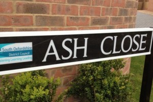
The new close that’s off Lime Road near Yarnells Hill, where Arrundale used to be and Woodbank Homes now are, is nAsh Close 22 Apr 14amed Ash Close. This is in the Vale of White Horse District Council area.

I snapped a shot of the road sign the day it went up 22 Apr 14.  We’ve  complained to the Vale that we aren’t in South Oxfordshire District. Or, does the recent co-location of staff have a more serious message — that we are now part of SODC? Surely not.

Ever since the current administration decided to relocate the (already shared) Vale staff to the SODC offices in Crowmarsh, we’ve been reassured repeatedly that this co-location was a cost saving measure and in no way indicated a merging of the two councils.

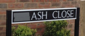
On 29 Apr I noticed a change and snapped another shotAsh Close 29 April 14:

I’m 70% amused and 30% irritated. I heard that in a Vale by-election in April, ballot papers were printed with SODC instead of Vale of White Horse.

This isn’t good enough.


Vale objects to Botley Rd Waitrose

The Vale filed its objection to the proposed Waitrose in West Oxford on Botley Road at the site where MFI used to be.

You can read it on Dropbox here: Vale Objection to Waitrose

Doric did their own objecting, and you can read it on the Oxford City planning site here: Doric Objection to Waitrose

For info, the reference number for the planning applicaiton is 14/00067/FUL. It was registered in January 2014 and is currently under consideration (consultation is closed).


If we get a gym in West Way…

I’m becoming more concerned about how Doric’s plan for a pay-as-you-go gym will affect the Brookes sports services. In particular, I worry about the long term financial viability of the popular swimming pool used by hundreds of local people.

The Brookes Sports Centre is largely supported by community memberships. Only a small percentage of money comes from students and the university. These local memberships subsidise the cost of the pool, just barely.

I fear a loss of memberships at Brookes would mean the pool would be no longer affordable.

That would be an irreplaceable loss to our school children and other people who swim there.

Free Parking Does Not Boost Business

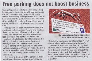
from Aug 2012, issue 245, of Parking Review

The British Parking Association chose a photo of the Vale Tories’ favourite poster boy, Free 2-hr Parking, to illustrate their article about how free parking is not of any benefit to local businesses.

Click on the photo to make it big enough to read.

If free parking has never been shown to benefit local businesses, the only possible reason for the Tories spending millions of pounds of public money on this project was to buy votes.

They did that. Promised free parking, won the election.

So now, a year later, how to the local shop-keepers feel about the efficacy of the Tory free parking scheme? Let’s go find out, shall we? Now, who has some copies of local newspapers I can scan?

Keep North Hinksey Parish Together

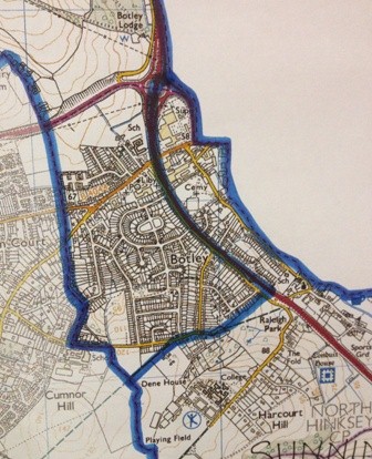
Poposed district ward boundary

Last night, at the full council meeting, I argued against the Tory-led proposal to split off a small part of North Hinksey parish and put it in another district ward with areas further to the south. I was voted down, pretty much across party lines. There was one interesting exception: I was supported by Tory Councillor Jane Crossley, of Sunningwell and Wooton. But the other local member for North Hinksey and Wytham, Tory Cllr Eric Batts, voted against my proposal, and FOR splitting off the southeastern part of North Hinksey into a ward with Boars Hill and Sunningwell.

I’ll keep fighting to keep the parish in the same district ward.

Here’s what I said last night:

LGBCE (Local Government Boundary Commission for England) have explicit criteria for making boundary changes. One is, ‘Provide boundaries that reflect natural communities’. The Vale working group agreed another criteria, ‘Use whole parishes as building blocks wherever possible’.

This proposal splits the parish of North Hinksey along the A34 and along an arbitrary boundary on the west side of the A34, solely to achieve electoral equality, and at the cost of community cohesion.

Other communities have benefitted from a more rational approach to their new boundaries: the Chilton parish is preserved, as is the town of Faringdon, for reasons to do with community cohesion and avoidance of subdivision of natural boundaries. Here’s what officers say about these two communities:

  • To remove part of the town (Faringdon) and place it in another ward to achieve electoral equality, would represent a wholly artificial construct that the local electorate would not recognise.
  • This ward (Blewbury) comprises three parishes in the south-eastern corner of the district. The electorate is quite high but the alternative would be to sub-divide Chilton parish along the line of the A34. We do not favour this because the village lies to one side of the road and the school and new housing to the other and we would be sub-dividing a natural community if we did so.

North Hinksey parish is a natural community in the same way that Faringdon and Chilton are, and should be preserved in the same way as those two communities have been.

With nearly 4000 electors, North Hinksey parish is too big for a single one-member ward, and too small for two wards. The tabled proposal would split off a fraction of the parish and combine it with other areas further south to make up the electoral numbers. Essentially, everything east of the A34, and south of Lime Road, would be part of a ward with other distant villages with which there are no ties. It’s a far better idea to keep all of North Hinksey parish together, and add to it the several outlying areas of Wytham, South Hinksey, Boars Hill and Sunningwell to make the numbers large enough for a two member ward. Electoral equality is still achieved. The combined electorate of the two proposed wards is about 5000; that’s a 3% variance, which is well within demonstrated tolerance. No natural community boundaries are shattered.

There are more specific reasons to not split up North Hinksey Parish.

  1. The Lime Road development will soon bring 150 new homes to the middle of North Hinksey parish. Under the current proposal, this new estate would not be in the ward with most of North Hinksey parish, but in the ward with Sunningwell. The development of so many new homes in North Hinksey parish is a huge concern with local people. New residents will use North Hinksey services; the impact will be on local shops, schools and doctors. They will use local recreational amenities and local roads. Keeping the new homes with North Hinksey supports better planning control in a rapidly growing community and will enable better Localism with a community-minded responsibility for local issues.
  2. When the A34 was built in the middle of the 20th century, it sliced North Hinksey parish in half, and local people have worked hard ever since to keep both sides linked up. Pedestrian underpasses mean residents on the east side of the highway can still access their shops, schools, churches and other services on the west side. This proposal would further split the eastern part from the main part of the parish on the west, and  undermine the efforts everyone has made to keep the parish together over the years.

Please support the amendment to keep North Hinksey together. There are precedents, and it meets the criteria of LGBCE and the Vale working group: it provides boundaries reflecting the natural communities in the north east corner of the Vale, and it uses parishes as the building blocks.

Neighbourhood Planning

Neighbourhood Planning Briefing Event

The Localism Act 2011 has introduced new powers for local people to help shape the places in which they live.  The Act is a central pillar of the government’s new approach to empowering local communities and encouraging more collaborative working with local authorities. One of the most important changes is the introduction of neighbourhood planning.

To further explain the benefits of collaborative working and the neighbourhood planning process, South Oxfordshire District Council and the Vale of White Horse District Council are organising an event for our town and parish councils across the two districts.

The purpose of the event will be to:

  • provide information to town and parish councils on neighbourhood planning in light of the new regulations and the National Planning Policy Framework;
  • place neighbourhood planning in context, alongside other forms of community led planning and policy work undertaken by South Oxfordshire District Council; and
  • gauge the level of interest of town and parish councils in neighbourhood planning.

The event will be held:  Time: 6 – 8.00pm   Date: Monday 16 July 2012   Venue: Guildhall, Abingdon

It will take the form of a short presentation given by council officers followed by a breakout discussion session on the issues in your local area and how these might relate to neighbourhood planning.  Oxfordshire Rural Community Council will also be in attendance to give further support and guidance on their role in community led planning.